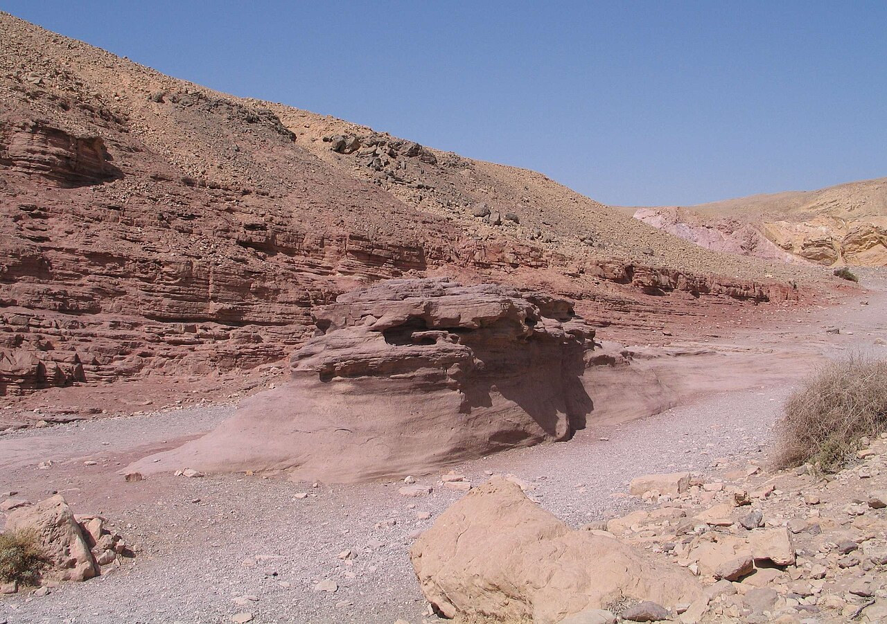
The Red Canyon is a narrow gorge of red sandstone in the Eilat Mountains, north of the city off Route 12. It is one of the main sites of the Eilat Mountains Nature Reserve. The walk through it includes a few small dry drops that you climb down using fixed railings and metal pegs.
The trail is not always open. In late October 2026, after heavy floods, the Israel Nature and Parks Authority closed every hiking trail in the Eilat Mountains. In its list of closed trails, dated 8 November 2026, INPA still shows the Red Canyon as closed to hikers. So the first step in planning a Red Canyon Eilat outing is to check its status on the day. This guide explains how to do that, and what to expect once you are there.
Is the Red Canyon open? How to check before you go
The canyon sits inside a nature reserve managed by the Israel Nature and Parks Authority (INPA, known in Hebrew as Rashut HaTeva VeHaGanim). INPA decides when trails open and close, and it can close them quickly.
On Wednesday 28 October 2026, INPA announced that all trails in the Eilat Mountains and other southern desert areas would close to hikers after the floods. In its own flood notice, INPA said hiking in southern nature reserves and national parks was banned until trail checks were finished and flood damage repaired. It said updates on reopenings would be posted on its website. As of 8 November 2026, INPA's list of trails closed for safety reasons includes the Red Canyon and the northern Nahal Shani routes (black and green markings), and entry is forbidden until further notice. The situation changes as repairs go ahead, so check the INPA page again on the day you plan to go.
Floods have hit this canyon before. On one earlier occasion, the Red Canyon trail closed for about three weeks after a flood damaged its ladders and safety railings. It reopened once they were fixed.
Heat can close trails too. During heatwaves, INPA can ban entry to all open-area hiking trails in its reserves and parks. When it does, it points the public to the Israel Meteorological Service (IMS) forecast and its own information line, *3639.
Where to check on the morning you go:
- The INPA website, parks.org.il. Look at the Red Canyon trail page and the site's latest notices about closures.
- INPA's information line, *3639.
- The IMS forecast, for heat and rain warnings.
- Road status for Route 12, the road you use to get there (more on this below).
What the Red Canyon Eilat landscape looks like
The canyon lies in the course of Nahal Shani. Nahal is the Hebrew word for a stream or wadi, which in the desert is usually a dry riverbed. INPA describes the stream cutting a grooved canyon high in the Eilat Mountains, with rock formations, bright red sandstone, and layers of clay and gypsum with a greenish tint.
The Society for the Protection of Nature in Israel (SPNI) explains that the canyon formed as a stream cut into cracks in soft sandstone. That is why the walls are narrow and shaped by water, even though the streambed is dry most of the time.
The setting is big. The Eilat Mountains reserve covers about 415,000 dunams, which is roughly 415 square kilometres (a dunam is 1,000 square metres). It runs from the edge of the Uvda Valley in the north to the Taba crossing in the south. INPA calls the area an extreme desert, with very high temperatures and very steep terrain. On the reserve's page, the Red Canyon appears among its main sites, alongside other narrow canyons carved into sandstone.
What the Red Canyon hike is like
This is not a flat stroll. Inside the canyon, SPNI describes three small dry falls: steps in the streambed where water pours over during a flood but which are dry the rest of the time. You get down them with a fixed railing and metal pegs set into the rock. INPA has also mentioned ladders and safety railings along the trail.
Sources disagree on how hard the walk is. Descriptions range from easy to challenging, so we are not giving it a grade. A better approach is to read INPA's own trail description and compare it honestly with your group. Think about anyone who might struggle to climb down short sections on metal fixtures, or who is uneasy with heights.
Remember that these fixtures sit in a floodway. They have been damaged before, so don't assume they will look exactly as a guidebook or an old video shows them. We are also not giving a trail length or walking time, because published figures vary from source to source. Check the route on INPA's page.
Getting to the Red Canyon from Eilat
According to INPA's directions, you drive north from Eilat on Route 12, the road that runs along the Egyptian border. Watch for a signposted turn-off onto a marked dirt road leading to the Red Canyon.
Published distances and drive times differ, so set your navigation app to the site and use the INPA page alongside it. Route 12 closes at times. During the October 2026 floods, police closed it along with every other road into and out of Eilat. It has also been closed on and off for a planned test by Rafael, the Israeli defence company, near Eilat. So check the road's status on the day, as well as the trail's.
When to go, and how to stay safe on an Eilat desert hike
The Eilat Mountains get very hot, so the cooler months are the natural time to plan a walk here. For what each month is actually like, see our guide to Eilat in winter. If you are planning around the December school holiday, our Hanukkah in Eilat 2026 guide covers the dates.
INPA publishes safe-hiking rules that apply here. In short:
- Plan your trip in advance.
- Check that the route suits the ages and fitness of everyone in your group.
- Don't hike on sharav days. A sharav is a spell of hot, dry desert heatwave weather.
- Don't hike when floods are possible.
- Take your rubbish home with you.
Flash floods are the most serious risk in a canyon like this. INPA once rescued a hiker caught by a flood inside the Red Canyon. It stresses that entering a flowing streambed, on foot or by vehicle, is strictly forbidden until the water has fully gone down.
Floods also bring a second hazard. In the same flood notice, INPA warned that flowing water may have moved unexploded rockets, shells or other explosives. If you see anything that looks like ordnance, don't touch it and keep well away.
Making a day of it from central Eilat
A Red Canyon morning fits well with an afternoon by the sea. The mountains are best in the cooler part of the day, and once you are back in town you can switch to swimming or simply resting. Central Park Residence is a 6-minute walk from the sea, in the centre of Eilat (see our location).
Every apartment has a fully equipped kitchen. That makes it easy to pack food and water the night before, so you can leave early without hunting for supplies. Keep the plan flexible, though: if the trail or Route 12 is closed that day, move the hike to another day.
Practical tips
- Check on the morning itself, not the night before. Use the INPA website and the *3639 line.
- Read the IMS forecast for heat and flood warnings, and skip the hike if either is likely.
- Check Route 12 before you set off, since it closes in floods and occasionally for other reasons.
- Keep your hands free for the descents. A backpack is easier than bags you have to carry.
- Pack food and water the night before so you can start early.
- Never enter a streambed with water flowing in it, and wait until it has fully gone down.
- Leave suspicious objects alone, especially after floods.
- Take all your rubbish home.
FAQ
Is the Red Canyon open today?
We can't answer that in an article, because the status changes. Floods and heatwaves both lead INPA to close trails, sometimes for weeks while damage is repaired. Check parks.org.il or call *3639 on the day you plan to go.
Is the Red Canyon suitable for children?
It depends on the children and the adults with them. The walk includes small dry drops that you climb down using railings and metal pegs, and sources disagree on how hard it is. INPA's advice is to check that a route suits the ages and fitness of everyone taking part, so read its trail description first.
How far is the Red Canyon from Eilat?
It is north of Eilat, reached from Route 12 by a signposted, marked dirt road. Published distances and drive times vary, so use a navigation app and INPA's directions.
Is there an entrance fee, and what are the opening hours?
We don't give fees or hours here, because we could not confirm current details from an official source. Check the INPA page for the Red Canyon or call *3639 before you go.
What happens if it rains?
Rain can bring flash floods, and INPA strictly forbids entering a flowing streambed until the water has fully gone down. After floods, trails may stay closed until they have been checked and repaired. Roads, including Route 12, may close too.
If you are looking for a place to stay in Eilat while you plan desert walks and beach afternoons, you are welcome to see our suites. Each one has its own kitchen, and the sea is a short walk away. Current prices and availability are on our booking page, and if you have a question, just ask us on WhatsApp.
Sources
- Trails closed for safety reasons, 8 Nov 2026 (Israel Nature and Parks Authority)
- הקניון האדום ונחל שני דרומי - המלצה למסלול טיול בשמורת טבע הרי אילת (Israel Nature and Parks Authority)
- שמורת טבע מסיב הרי אילת (Israel Nature and Parks Authority)
- חולץ מטייל בקניון האדום שנקלע לשיטפון (Israel Nature and Parks Authority)
- כללים מצילי חיים: מטיילים נכון - חוזרים לשלום (Israel Nature and Parks Authority)
- הקניון האדום: קסם שהמים עיצבו (SPNI)
- רשות הטבע והגנים: נפתח מחדש מסלול הטיול בקניון האדום בהרי אילת (ynet)
- אחרי השיטפונות בדרום: האתרים והמסלולים שנסגרו למטיילים (Israel Hayom)
- Amid intense heatwave, Parks Authority imposes ban on entering hiking trails until Saturday (The Times of Israel)
- Due to Weather: All Roads Leading to and from Eilat Blocked to Traffic (Ynetnews)
- בשל ניסוי: פיצוצים יישמעו מחר ומחרתיים באזור אילת, כביש 12 ייסגר לסירוגין (ynet)